Severe Thunderstorms Threaten Midwest with Baseball-Size Hail

What's Happening?
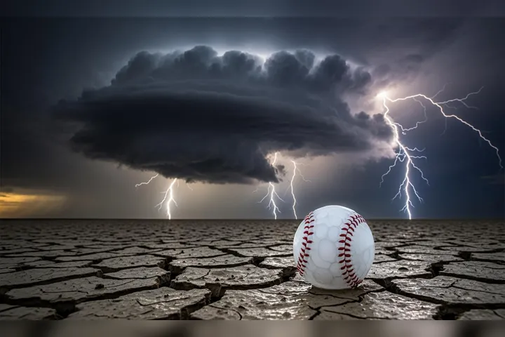
Severe thunderstorms are forecasted to impact parts of the Midwest, particularly in Illinois, Indiana, and Ohio. The National Weather Service Storm Prediction Center has issued an enhanced risk warning for severe weather, indicating a Level 3 out of 5 threat. This includes areas such as Peoria and Bloomington in Illinois, Indianapolis and Fort Wayne in Indiana, and Columbus, Toledo, and Cleveland in Ohio. The storms are expected to produce large, destructive hail, potentially the size of baseballs, especially in north central Indiana. The thunderstorms are anticipated to develop as early as 2 p.m. local time, with the potential for rotating supercells. While the risk of tornadoes is low, the conditions are conducive to hail production due to steep mid-level lapse rates and dry air at mid-levels.
Why It's Important?
The severe weather poses significant risks to communities across the Midwest, potentially causing damage to property and infrastructure. Large hail can damage vehicles, homes, and crops, leading to economic losses for individuals and businesses. The enhanced risk warning highlights the need for residents to stay informed and prepared for possible severe weather conditions. Emergency services and local governments may need to respond to damage and ensure public safety. The potential for rotating supercells also raises concerns about the possibility of tornadoes, which, although low, could have devastating impacts if they occur.
What's Next?
As the thunderstorms develop, residents in the affected areas should monitor weather updates and heed any warnings or advisories issued by local authorities. The storms are expected to merge into squall lines or clusters after 9 p.m. Central time, continuing to move along the frontal boundary. This could lead to localized flooding in areas where heavy rains persist. Emergency management agencies may need to coordinate responses to any damage or disruptions caused by the severe weather. The situation underscores the importance of preparedness and effective communication between weather services and the public.
AI Generated Content
For the benefit of users - Parts of this article may include content generated using AI tools. Our teams are making active and commercially reasonable efforts to moderate all AI generated content. Our moderation processes are improving however our processes are carried out on a best-effort basis and may not be exhaustive in nature. We encourage our users to consume the content judiciously and rely on their own research for accuracy of facts. We maintain that all AI generated content on our platform is for entertainment purposes only. To know more about how we use AI, you can write to us at
Close AI Generated Content