Soon-to-be Hurricane Nolo to threaten Hawaii with 'catastrophic' floods

An approaching system is raising concern in Hawaii for a "catastrophic" threat from yet another tropical cyclone, for the third time this year.
Heavy rain is forecast to return to the eastern Hawaiian Islands
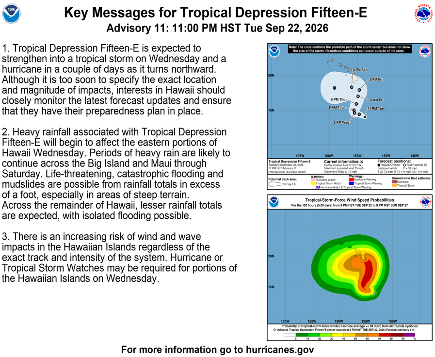
as a storm expected to become Tropical Storm Nolo on Sept. 23 forms to the south of the islands, bringing potentially "catastrophic flooding" to areas still recovering from Hurricane Lala flooding.
As of 5 a.m. HST on Sept. 23, the center of the depression was 320 miles south-southeast of South Point, Hawaii, and about 525 miles south-southeast of Honolulu, with sustained winds of 35 mph.
Sharp turn to the north expected
A sharp turn to the north or north-northeast is forecast on Thursday, Sept. 24, taking the storm near the Big Island of Hawaii on Friday, as a hurricane. Swells are expected to arrive Friday, spreading west and building over the weekend, creating "life-threatening surf and rip current conditions."
The center of the storm is forecast to be roughly 100 miles south-southeast of the Big Island late Friday night, with sustained winds of 110 mph, just below Category 3 hurricane strength, according to the hurricane center's forecast.
Heavy rain in the forecast
Heavy rain is forecast to start on Wednesday, Sept. 23, and continue through Sept. 26, the hurricane center said. "Life-threatening, catastrophic flooding and mudslides are possible from rainfall totals in excess of a foot, especially in areas of steep terrain."
Rainfall amounts over three days could exceed 20 inches at higher elevations on the Big Island, with widespread rainfall totals over Hawaii and the eastern side of Maui. But the rainfall rate is expected to have more impact than the total rainfall, the weather service said.
More: El Niño goes wild: Pacific Ocean under siege from tropical cyclones
The southeast Big Island "is vulnerable due to ongoing recovery from the flooding during (Hurricane) Lala," said John Bravender, a meteorologist with the National Weather Service in Honolulu.
Risks for wind and wave impacts are also forecast to increase regardless of the storm's exact track or intensity, and hurricane or tropical storm watches could be issued later today.
"Although it is too soon to specify the exact location and magnitude of impacts, interests in Hawaii should closely monitor the latest forecast updates and ensure that they have their preparedness plan in place," the hurricane center warned.
Flooding forecast for eastern Hawaiian Islands
A flood watch is in effect for the Big Island, Maui, Lanai, Molokai and Kahoolawe from noon Sept. 23 through the afternoon of Saturday, Sept. 26.
Heavy rain on the north side of the intensifying cyclone will develop on Wednesday, Sept. 23, over the Big Island, then spread westward to Maui. The weather service warns of potentially significant flooding, with landslides and possible property damage.
More: Hawaii faces flooding and mudslide risks as Lala moves away. Updates
World championship canoe race canceled
Organizers of the annual Na Wahine O Ke Kai, aworld championship women’s canoe race scheduled for Sunday, Sept. 27, have canceled the event. The Oahu Hawaiian Canoe Racing Association cited the expected rough conditions offshore. The race from Molokai to Oahu began in 1954 and has been canceled by extreme conditions twice before in 1980 and 2015.
Hurricane Polo menaces Mexico
Elsewhere in the Pacific, a slightly weakened Hurricane Polo was drifting northward in the Pacific on the morning of Sept. 23, about 165 miles south of Zihuatanejo, Mexico, with peak sustained winds of 150 mph. Tropical storm watches and warnings are in effect along the country’s southern coast.
The hurricane is forecast to begin moving westward by Sept. 24, then turn northward by Sept. 26 and approach the Southern California Baja Peninsula. The official forecast calls for the center of the hurricane to be roughly 200 miles west of Cabo San Lucas on the morning of Sunday, Sept. 27, as a hurricane, with peak sustained winds of 105 mph.
Polo rapidly intensified earlier in the week as it became a Category 5 hurricane with 180 mph winds, increasing its wind speeds by 95 mph in less than 24 hours.
More: Where is Hurricane Polo headed? See path tracker, spaghetti models
Odalys spins in the open Pacific
Hurricane Odalys has also joined the Pacific storm party this week.
As of 2 a.m. PDT, the center of Odalys was about 1,295 miles south-southwest of the southern tip of Mexico's Baja California Peninsula. It had maximum sustained winds of 75 mph, the hurricane center said.
It poses no threat to any land areas.
Odalys is forecast to hit peak intensity on the evening of Sept. 24, then weaken. The potential still exists for Odalys, as a tropical storm, to have some interaction with Hurricane Polo, the hurricane center said in a forecast discussion. The centers of the two storms are forecast to be roughly 600 miles apart on the morning of Sept. 27.
Atlantic remains hurricane-free
In the Atlantic basin, forecasters are watching two areas of disturbed weather for possible development into tropical depressions, the hurricane center said. However, due to strong upper-level winds that will act to shear the tops of the storms off, neither storm is forecast to reach hurricane strength, which will continue the trend that's prevented hurricanes from forming in the Atlantic this season.
Polo pushes monsoonal rains into New Mexico
A strong band of monsoonal moisture pushing ahead of Hurricane Polo is soaking much of New Mexico.
Overnight on Sept. 22, heavy rain sent the Rio Hondo River up more than six feet before it crested, according to the weather service office in Albuquerque. The rain is expected to continue, contributing to the risk of flash flooding through Thursday, particularly in eastern New Mexico.
Doyle Rice and Dinah Voyles Pulver are national correspondents for USA TODAY with a focus on weather and climate. Reach them at drice@usatoday.com and dpulver@usatoday.com.